
RedKalion
Atlantic Ocean Caribbean Sea Map | Vintage Maritime Art Print | RedKalion
Atlantic Ocean Caribbean Sea Map | Vintage Maritime Art Print | RedKalion
Couldn't load pickup availability
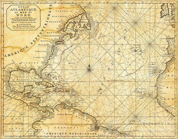
This vintage maritime map, titled 'Atlantic Ocean Caribbean Sea Vintage Maritime Map #1,' offers a captivating glimpse into historical cartography. Crafted with meticulous detail, it charts the intricate waterways and coastlines of the Atlantic Ocean and Caribbean Sea, reflecting the navigational knowledge and artistic flair of its era. The map's aged aesthetic, with subtle sepia tones and decorative elements, evokes the spirit of exploration and trade that defined these regions.
Historical Context of the Atlantic Ocean Caribbean Sea Map
Dating from a period of significant maritime expansion, this map serves as a cultural artifact, illustrating the geopolitical and economic importance of the Atlantic Ocean and Caribbean Sea. Its design incorporates traditional cartographic symbols, such as compass roses and rhumb lines, which were essential for sailors navigating these vast waters. The inclusion of place names and topographical features highlights the evolving understanding of geography during the Age of Discovery.
Stylistic Analysis of This Caribbean Sea and Atlantic Ocean Map
Artistically, the map blends functional precision with ornamental charm. The use of hand-drawn illustrations and typography adds a personal touch, while the color palette—dominated by earthy hues—enhances its vintage appeal. This piece not only informs but also decorates, making it a versatile addition to any space seeking a touch of historical elegance.
Print Specifications & Materials
- Available Sizes: 75×100 cm / 30×40″, 40×50 cm / 16×20″, 21×29.7 cm / 8×12″
- Paper Finishing: Matte, uncoated, natural white (off-white)
- Acid-Free: pH above 7 to prevent yellowing over time
- Paper Weight: 250 gsm (110 lb) | Thickness: 0.29 mm (11.4 mils)
- Sustainable Paper: FSC-certified
At RedKalion, we specialize in premium museum-quality art prints, ensuring that this Atlantic Ocean Caribbean Sea map is reproduced with archival-grade materials for lasting beauty and authenticity. Trust our expertise to bring historical art into your home with unmatched fidelity.


Discover Unlimited Art Possibilities
At RedKalion, you can find virtually any artwork from any artist, available in a wide range of sizes to perfectly match your space.
If you didn’t find what you’re looking for, contact us at support@redkalion.com . We will source any artwork and produce it in any size and format you need, including art prints, posters, canvas, framed pieces, framed canvas, and more.
For dedicated art enthusiasts, we also offer handcrafted replicas of any artwork, carefully painted by highly skilled artists using traditional techniques.
For custom requests, contact us at support@redkalion.com .
What is the historical significance of this Atlantic Ocean Caribbean Sea map?
This vintage map reflects maritime exploration during the Age of Discovery, detailing navigational routes and geographical features of the Atlantic Ocean and Caribbean Sea with traditional cartographic symbols.
What materials are used for this fine art print of the Caribbean Sea and Atlantic Ocean map?
We use FSC-certified, acid-free paper with a matte finish and 250 gsm weight to ensure archival quality and prevent yellowing for this premium art print.
How is this vintage maritime map shipped to ensure it arrives safely?
We ship this Atlantic Ocean Caribbean Sea map in protective packaging, with tracking provided, to prevent damage during transit for secure delivery.
How long will this art print of the map of Caribbean Sea and Atlantic Ocean last without fading?
With acid-free, archival-grade paper, this print resists fading and yellowing, maintaining its quality for decades under proper display conditions.
What decorative styles complement this Atlantic Ocean Caribbean Sea vintage map?
This map pairs well with nautical, vintage, or minimalist decor, adding historical charm to living rooms, offices, or studies as a focal point.
Are there any specific geographical details highlighted on this map of the Caribbean Sea and Atlantic Ocean?
Yes, it includes coastlines, islands, and navigational lines like rhumb lines, emphasizing key trade and exploration routes in the region.
How was this vintage maritime map originally created or sourced?
Based on historical cartographic techniques, it replicates hand-drawn maps from maritime archives, preserving authentic details for modern reproduction.