
RedKalion
Central America Map Panama Canal Art Print | RedKalion
Central America Map Panama Canal Art Print | RedKalion
Couldn't load pickup availability
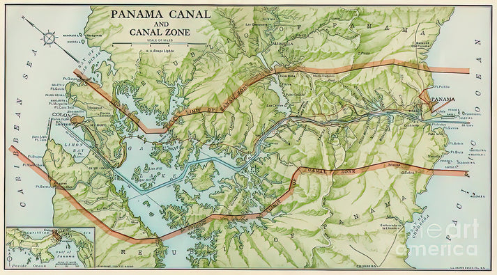
This 1913 map of the Panama Canal Territory is a pivotal historical document, capturing Central America at a moment of profound geopolitical transformation. Created during the canal's construction, it blends cartographic precision with the aesthetic sensibility of early 20th-century scientific illustration.
Historical Significance of the Central America Map Panama Canal
The map details the newly established Canal Zone, a 10-mile-wide U.S.-controlled territory, against the broader Central American landscape. It reflects the era's imperial ambitions and engineering optimism, serving as both a practical navigational tool and a symbol of American hemispheric influence.
Cartographic Style and Details
Executed with meticulous linework and subdued coloration, the map emphasizes topography, hydrography, and infrastructure. Key features include the canal's planned route, locks, settlements like Panama City and Colón, and the surrounding mountain ranges and coastlines of Central America.
Print Specifications & Materials
- Available Sizes: 75×100 cm / 30×40″, 40×50 cm / 16×20″, 21×29.7 cm / 8×12″
- Paper Finishing: Matte, uncoated, natural white (off-white)
- Acid-Free: pH above 7 to prevent yellowing over time
- Paper Weight: 250 gsm (110 lb) | Thickness: 0.29 mm (11.4 mils)
- Sustainable Paper: FSC-certified
RedKalion's premium art print preserves the map's archival integrity, offering a tangible connection to a defining chapter in Central American and global history. Ideal for historians, educators, or enthusiasts of cartography and the Panama Canal.


Discover Unlimited Art Possibilities
At RedKalion, you can find virtually any artwork from any artist, available in a wide range of sizes to perfectly match your space.
If you didn’t find what you’re looking for, contact us at support@redkalion.com . We will source any artwork and produce it in any size and format you need, including art prints, posters, canvas, framed pieces, framed canvas, and more.
For dedicated art enthusiasts, we also offer handcrafted replicas of any artwork, carefully painted by highly skilled artists using traditional techniques.
For custom requests, contact us at support@redkalion.com .
What does this Central America map of the Panama Canal depict?
This 1913 map shows the Panama Canal Territory and Central America during construction, detailing the Canal Zone, topography, and key infrastructure with historical accuracy.
What paper is used for this Panama Canal map art print?
We use 250 gsm, FSC-certified, acid-free paper with a matte finish to ensure archival quality and prevent yellowing, replicating the map's original aesthetic.
How is this Central America map shipped?
Prints are carefully packaged in protective tubes and shipped globally with tracking; delivery times vary by location for safe arrival.
Will this Panama Canal map print last over time?
Yes, the acid-free, pH-balanced paper and archival inks ensure longevity, resisting fading and deterioration for decades under proper display conditions.
Who created the original 1913 map of the Panama Canal Territory?
The map was produced by U.S. government cartographers in 1913, reflecting official surveys during the canal's construction era in Central America.
What makes this map historically significant for Central America?
It documents the geopolitical shift as the U.S. established the Canal Zone, highlighting Central America's role in early 20th-century global trade and engineering.