
RedKalion
Chula Vista Map Art Print | Premium City Cartography | RedKalion
Chula Vista Map Art Print | Premium City Cartography | RedKalion
Couldn't load pickup availability
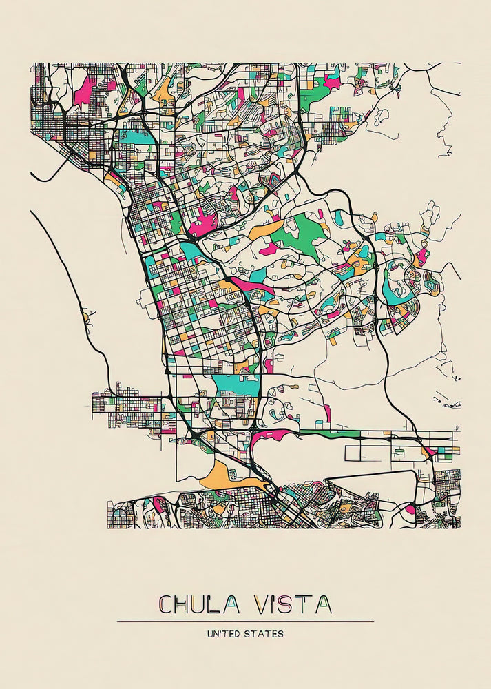
This Chula Vista map art print captures the urban layout and coastal geography of California's second-largest city in San Diego County. Created with precision cartographic techniques, it details neighborhoods like Eastlake, Otay Ranch, and the historic downtown, set against the backdrop of San Diego Bay and the Sweetwater River. The design blends functional street mapping with aesthetic appeal, using subtle color palettes and clean typography to highlight key landmarks, parks, and infrastructure.
Historical Context of Chula Vista Cartography
Chula Vista's development from agricultural lands in the late 19th century to a modern suburban hub is reflected in its evolving map designs. Early surveys by land speculators and later city planners emphasized its grid-like street patterns and proximity to the U.S.-Mexico border. This print draws from archival sources, incorporating elements that trace the city's growth through annexations and community planning efforts.
Stylistic Analysis of This City Map Print
The map employs a minimalist approach, reducing visual clutter to focus on geographic accuracy and readability. Lines denote major roads like Interstate 805 and State Route 125, while shaded areas differentiate residential zones from commercial districts. A muted color scheme—featuring soft blues for water bodies and earthy tones for land—creates a sophisticated, gallery-ready piece that complements contemporary interiors.
Print Specifications & Materials
- Available Sizes: 75×100 cm / 30×40″, 40×50 cm / 16×20″, 21×29.7 cm / 8×12″
- Paper Finishing: Matte, uncoated, natural white (off-white)
- Acid-Free: pH above 7 to prevent yellowing over time
- Paper Weight: 250 gsm (110 lb) | Thickness: 0.29 mm (11.4 mils)
- Sustainable Paper: FSC-certified
RedKalion's Chula Vista map art print serves as both a decorative focal point and an educational resource, ideal for residents, historians, or design enthusiasts. Its archival-quality materials ensure longevity, making it a thoughtful gift or personal keepsake that celebrates this dynamic Southern California city.

Discover Unlimited Art Possibilities
At RedKalion, you can find virtually any artwork from any artist, available in a wide range of sizes to perfectly match your space.
If you didn’t find what you’re looking for, contact us at support@redkalion.com . We will source any artwork and produce it in any size and format you need, including art prints, posters, canvas, framed pieces, framed canvas, and more.
For dedicated art enthusiasts, we also offer handcrafted replicas of any artwork, carefully painted by highly skilled artists using traditional techniques.
For custom requests, contact us at support@redkalion.com .
What areas of Chula Vista are featured on this map art print?
This print includes neighborhoods like Eastlake, Otay Ranch, downtown Chula Vista, and landmarks such as the Olympic Training Center and San Diego Bay. It covers major roads and geographic features for a comprehensive view.
What type of paper is used for this fine art print?
We use FSC-certified, acid-free paper with a matte finish, weighing 250 gsm. This premium material prevents yellowing and ensures vibrant, long-lasting color reproduction for your Chula Vista map.
How is this Chula Vista map shipped to protect it during delivery?
Prints are carefully rolled in a sturdy tube with protective layers to prevent damage. We offer tracked shipping with secure packaging to ensure your city map art arrives in perfect condition.
Will this art print fade or deteriorate over time?
No, the archival-quality, acid-free paper and fade-resistant inks maintain the print's integrity for decades, making it a durable addition to your home or office decor.
What are the available sizes for this Chula Vista map print?
Choose from 75×100 cm (30×40″), 40×50 cm (16×20″), or 21×29.7 cm (8×12″) to fit different wall spaces and display preferences for your California city map.
How does this map reflect Chula Vista's historical development?
It incorporates elements from historical surveys, showing the city's evolution from agricultural plots to urban expansion, with grid patterns and key infrastructure changes over time.
What design techniques make this map suitable for gallery display?
The minimalist style, clean typography, and muted color palette emphasize geographic accuracy while creating an aesthetically pleasing piece that blends with modern interior design.