
RedKalion
Helena, Montana City Map Art Print | Premium Cartographic Reproduction | RedKalion
Helena, Montana City Map Art Print | Premium Cartographic Reproduction | RedKalion
Couldn't load pickup availability
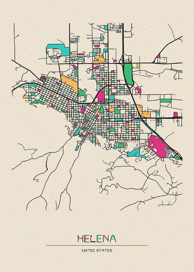
This Helena, Montana city map art print captures the historic urban layout of Montana's capital, established during the 1864 gold rush. Cartographers meticulously plotted the city's grid-like streets, reflecting late 19th-century American frontier planning. The map details landmarks like the Montana State Capitol and Last Chance Gulch, offering a window into Helena's evolution from mining camp to political center.
Historical Context of the Helena Map
Created in the post-Civil War era, this Helena MT map of city illustrates the rapid settlement of the Northern Rockies. The design emphasizes practical navigation for prospectors and settlers, with clear demarcations of residential, commercial, and governmental zones. Its aesthetic blends utilitarian clarity with subtle decorative elements, typical of period cartography.
Artistic Analysis of This City Map
As a Helena city map, this piece showcases precise linework and balanced typography, hallmarks of professional mapmaking. The color palette often features muted earth tones, highlighting topography and infrastructure. RedKalion's reproduction preserves these details, ensuring archival quality for display in homes or offices.
Print Specifications & Materials
- Available Sizes: 75×100 cm / 30×40″, 40×50 cm / 16×20″, 21×29.7 cm / 8×12″
- Paper Finishing: Matte, uncoated, natural white (off-white)
- Acid-Free: pH above 7 to prevent yellowing over time
- Paper Weight: 250 gsm (110 lb) | Thickness: 0.29 mm (11.4 mils)
- Sustainable Paper: FSC-certified
This Helena, Montana city map art print from RedKalion serves as both a decorative piece and historical document, ideal for enthusiasts of Western Americana or cartographic art. Our museum-quality standards guarantee a lasting tribute to Helena's legacy.

Discover Unlimited Art Possibilities
At RedKalion, you can find virtually any artwork from any artist, available in a wide range of sizes to perfectly match your space.
If you didn’t find what you’re looking for, contact us at support@redkalion.com . We will source any artwork and produce it in any size and format you need, including art prints, posters, canvas, framed pieces, framed canvas, and more.
For dedicated art enthusiasts, we also offer handcrafted replicas of any artwork, carefully painted by highly skilled artists using traditional techniques.
For custom requests, contact us at support@redkalion.com .
What historical period does this Helena, Montana city map represent?
This map depicts Helena in the late 19th to early 20th century, showcasing its development post-1864 gold rush, with landmarks like the state capitol.
What are the paper specifications for this Helena MT map art print?
It uses 250 gsm FSC-certified acid-free paper with a matte finish, ensuring archival longevity and preventing yellowing over decades.
How is this Helena city map shipped to ensure protection?
We ship it flat in reinforced packaging to prevent creasing, with tracking provided for secure delivery of your fine art print.
Will this Helena, Montana map art print fade over time?
No, our acid-free paper and pigment-based inks resist fading, maintaining color accuracy for generations under normal display conditions.
What sizes are available for this Helena MT map of city print?
Available in 75×100 cm, 40×50 cm, and 21×29.7 cm, offering flexible options for home or office decor.
How accurate is the cartographic detail in this Helena city map reproduction?
RedKalion's reproduction preserves original linework and typography with high precision, based on historical sources for authentic representation.
Why was Helena's street grid designed in this specific layout?
The grid reflects practical frontier planning from the 1860s, facilitating easy navigation for miners and settlers in the mountainous terrain.