
RedKalion
Louisiana Purchase Drawing: 1926 Engraving Art Print | RedKalion
Louisiana Purchase Drawing: 1926 Engraving Art Print | RedKalion
Couldn't load pickup availability
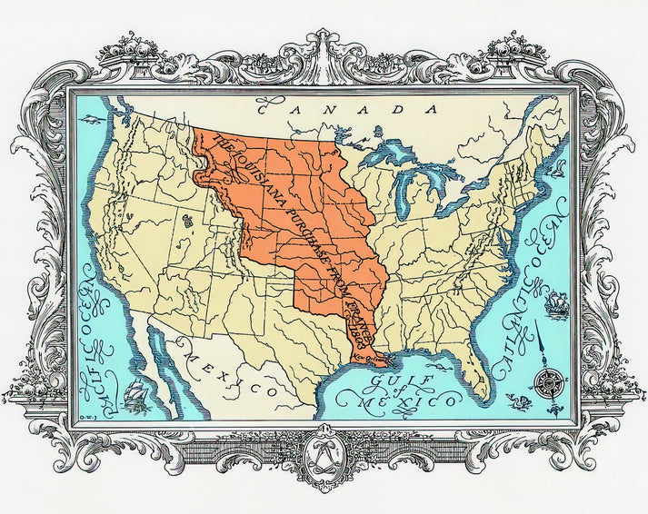
This 1926 engraving, titled 'Map of the Louisiana Purchase,' offers a detailed cartographic representation of the historic 1803 land acquisition. Created decades after the event, it reflects early 20th-century historical scholarship and engraving techniques, blending geographic precision with artistic craftsmanship. The map delineates the vast territory—approximately 828,000 square miles—acquired from France, spanning from the Mississippi River to the Rocky Mountains, and serves as both an educational tool and a piece of Americana.
Historical Context of the Louisiana Purchase Drawing
The Louisiana Purchase, negotiated under President Thomas Jefferson, doubled the size of the United States and reshaped its geopolitical landscape. This 1926 engraving was produced during a period of renewed interest in American expansionism and frontier history, likely for academic or commemorative purposes. Its creation aligns with the early 20th-century trend of visualizing historical narratives through detailed maps, making it a valuable artifact for historians and collectors alike.
Artistic Analysis of the 1926 Engraving
Executed in the engraving style prevalent in the early 1900s, this drawing employs fine lines and cross-hatching to render topographic features, boundaries, and textual annotations. The monochromatic palette emphasizes clarity and legibility, while the composition balances dense informational elements with open spaces to guide the viewer's eye. Stylistically, it bridges utilitarian mapmaking and decorative art, showcasing the engraver's skill in translating complex data into an aesthetically pleasing format.
Print Specifications & Materials
- Available Sizes: 75×100 cm / 30×40″, 40×50 cm / 16×20″, 21×29.7 cm / 8×12″
- Paper Finishing: Matte, uncoated, natural white (off-white)
- Acid-Free: pH above 7 to prevent yellowing over time
- Paper Weight: 250 gsm (110 lb) | Thickness: 0.29 mm (11.4 mils)
- Sustainable Paper: FSC-certified
RedKalion's premium art print of this Louisiana Purchase drawing ensures archival quality, capturing every intricate detail of the original 1926 engraving for display in homes, offices, or educational settings. Trust our expertise in museum-quality reproductions to bring historical artistry into your space.

Discover Unlimited Art Possibilities
At RedKalion, you can find virtually any artwork from any artist, available in a wide range of sizes to perfectly match your space.
If you didn’t find what you’re looking for, contact us at support@redkalion.com . We will source any artwork and produce it in any size and format you need, including art prints, posters, canvas, framed pieces, framed canvas, and more.
For dedicated art enthusiasts, we also offer handcrafted replicas of any artwork, carefully painted by highly skilled artists using traditional techniques.
For custom requests, contact us at support@redkalion.com .
What is depicted in this Louisiana Purchase drawing?
This 1926 engraving shows a detailed map of the Louisiana Purchase territory, including geographic boundaries, rivers, and annotations from the historic 1803 land acquisition.
What paper is used for this fine art print?
We use FSC-certified, acid-free paper with a matte finish and 250 gsm weight to ensure archival longevity and prevent yellowing over time.
How is this art print shipped and packaged?
Prints are shipped flat in sturdy packaging to prevent damage, with tracking provided for secure delivery of your Louisiana Purchase drawing.
Will this print fade or deteriorate over time?
No, our acid-free paper and archival inks resist fading and deterioration, preserving the Louisiana Purchase drawing for decades.
What sizes are available for this engraving print?
Available in 75×100 cm, 40×50 cm, and 21×29.7 cm sizes to fit various display needs for this historical map art print.
Why was this 1926 engraving created?
It was likely made for educational or commemorative purposes during a period of renewed interest in American history and expansionism.
What engraving techniques are visible in this drawing?
The map uses fine lines and cross-hatching typical of early 20th-century engraving to detail topography and boundaries clearly.