
RedKalion
Louisiana Purchase Map 1803 Art Print | Historical United States Map | RedKalion
Louisiana Purchase Map 1803 Art Print | Historical United States Map | RedKalion
Couldn't load pickup availability
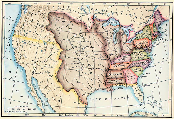
This 1803 Louisiana Purchase map is a pivotal historical document, capturing the moment when the United States nearly doubled its territory. Created in the era of Jeffersonian expansion, it delineates the vast lands acquired from France, stretching from the Mississippi River to the Rocky Mountains. The map's cartographic style reflects early 19th-century techniques, with hand-colored regions and engraved text, offering a window into the geopolitical ambitions of the young nation.
Historical Context of the Louisiana Purchase Map
The Louisiana Purchase of 1803, negotiated under President Thomas Jefferson, was a landmark transaction that added approximately 828,000 square miles to the U.S. This map visually chronicles that acquisition, showing boundaries before and after the deal. Its creation coincided with the Lewis and Clark Expedition, which aimed to explore the new territory, making it an essential artifact for understanding American westward expansion.
Artistic and Cartographic Analysis
As a fine art print, this map showcases the aesthetic precision of early American cartography. Features include detailed topographical elements, river systems like the Missouri and Mississippi, and annotations in period typography. The color palette, often muted earth tones, highlights territorial divisions and enhances readability, embodying the blend of scientific inquiry and artistic expression common in maps of this era.
Print Specifications & Materials
- Available Sizes: 75×100 cm / 30×40″, 40×50 cm / 16×20″, 21×29.7 cm / 8×12″
- Paper Finishing: Matte, uncoated, natural white (off-white)
- Acid-Free: pH above 7 to prevent yellowing over time
- Paper Weight: 250 gsm (110 lb) | Thickness: 0.29 mm (11.4 mils)
- Sustainable Paper: FSC-certified
At RedKalion, we specialize in museum-quality reproductions that honor historical integrity. Our archival prints ensure this Louisiana Purchase map from 1803 remains a durable and educational piece for your collection, ideal for historians, educators, and art enthusiasts seeking authentic representations of America's formative years.

Discover Unlimited Art Possibilities
At RedKalion, you can find virtually any artwork from any artist, available in a wide range of sizes to perfectly match your space.
If you didn’t find what you’re looking for, contact us at support@redkalion.com . We will source any artwork and produce it in any size and format you need, including art prints, posters, canvas, framed pieces, framed canvas, and more.
For dedicated art enthusiasts, we also offer handcrafted replicas of any artwork, carefully painted by highly skilled artists using traditional techniques.
For custom requests, contact us at support@redkalion.com .
What does this Louisiana Purchase map from 1803 depict?
This map shows the United States in 1803, highlighting the Louisiana Purchase territory acquired from France, which expanded U.S. borders westward to the Rocky Mountains.
What are the specifications of the art print paper?
The print uses 250 gsm, acid-free, FSC-certified paper with a matte finish to ensure archival quality and prevent yellowing over time.
How is the map shipped and delivered?
We ship worldwide in protective packaging, with delivery times varying by location; tracking is provided for all orders.
How long will the print last without fading?
With acid-free materials and proper display away from direct sunlight, the print can maintain its quality for decades without significant fading.
Who created the original 1803 Louisiana Purchase map?
The original was likely produced by American or European cartographers of the early 19th century, reflecting the period's geopolitical changes.
What makes this map historically significant?
It documents a key moment in U.S. expansion, illustrating the territorial gains from the Louisiana Purchase that shaped the nation's growth.