
RedKalion
Map of Paducah: Vintage 1889 City Street Art Print | RedKalion
Map of Paducah: Vintage 1889 City Street Art Print | RedKalion
Couldn't load pickup availability
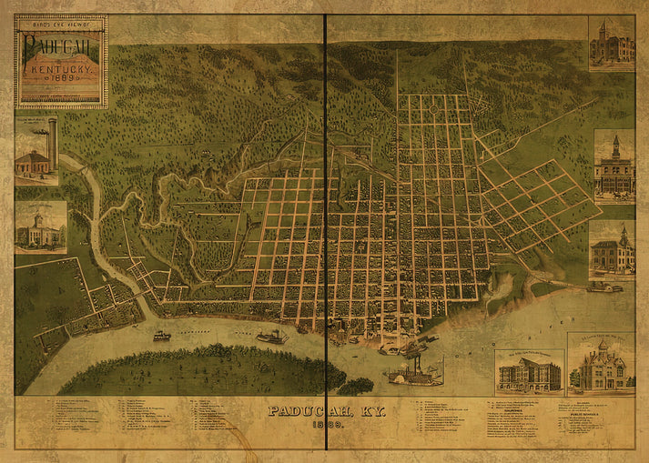
This 1889 Paducah map offers a historical snapshot of the city's urban layout during the late 19th century. Created as a detailed cartographic document, it captures street names, landmarks, and the evolving infrastructure of this Kentucky river town. The map serves as a valuable artifact for historians and art enthusiasts, reflecting the era's meticulous engraving techniques and aesthetic precision.
Historical Context of the 1889 Paducah Map
Produced during a period of post-Civil War reconstruction and industrial growth, this map highlights Paducah's strategic position along the Ohio River. It documents the city's expansion, including commercial districts and residential areas, providing insight into its development as a regional hub.
Stylistic Analysis of This Vintage Map
The map features intricate line work, typographic clarity, and a balanced composition typical of late Victorian cartography. Its design emphasizes functionality while retaining artistic elements like decorative borders and subtle shading, making it a compelling piece for display.
Print Specifications & Materials
- Available Sizes: 75×100 cm / 30×40″, 40×50 cm / 16×20″, 21×29.7 cm / 8×12″
- Paper Finishing: Matte, uncoated, natural white (off-white)
- Acid-Free: pH above 7 to prevent yellowing over time
- Paper Weight: 250 gsm (110 lb) | Thickness: 0.29 mm (11.4 mils)
- Sustainable Paper: FSC-certified
RedKalion's premium reproduction ensures this vintage Paducah map is preserved with archival quality, ideal for home or office decor. Trust our expertise in museum-grade prints to bring historical cartography to life.

Discover Unlimited Art Possibilities
At RedKalion, you can find virtually any artwork from any artist, available in a wide range of sizes to perfectly match your space.
If you didn’t find what you’re looking for, contact us at support@redkalion.com . We will source any artwork and produce it in any size and format you need, including art prints, posters, canvas, framed pieces, framed canvas, and more.
For dedicated art enthusiasts, we also offer handcrafted replicas of any artwork, carefully painted by highly skilled artists using traditional techniques.
For custom requests, contact us at support@redkalion.com .
What historical details are shown on this 1889 Paducah map?
This map displays Paducah's street grid, key buildings, and landmarks from 1889, reflecting its growth as a river port in Kentucky.
What paper is used for this vintage map art print?
We use FSC-certified, acid-free 250 gsm matte paper to ensure durability and prevent fading, ideal for archival display.
How is this Paducah map print shipped and packaged?
Prints are shipped flat in protective packaging to avoid damage, with tracking provided for secure delivery.
Will this map print last without yellowing over time?
Yes, the acid-free paper with a pH above 7 ensures long-term color stability and resistance to yellowing.
What sizes are available for this Paducah Kentucky map?
Available in 75×100 cm, 40×50 cm, and 21×29.7 cm to fit various framing and display needs.
Why was Paducah significant in the late 19th century?
Paducah was a key Ohio River port, facilitating trade and transportation during Kentucky's industrial expansion post-Civil War.
How does this map reflect Victorian cartographic style?
It features precise engraving, clear typography, and decorative elements typical of late 19th-century mapmaking aesthetics.