
RedKalion
Map of Stockton California Art Print | Vintage City Map | RedKalion
Map of Stockton California Art Print | Vintage City Map | RedKalion
Couldn't load pickup availability
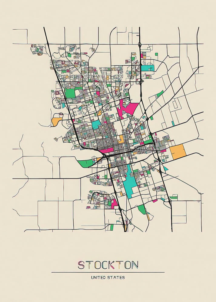
This vintage map of Stockton, California, captures the city's historic layout and growth during the late 19th and early 20th centuries. Created as a premium art print, it offers a detailed cartographic view of Stockton's streets, landmarks, and waterways, reflecting its development as a Central Valley hub.
Historical Context of the Stockton Map
Stockton, founded in 1849 during the California Gold Rush, evolved from a mining supply point into a major agricultural and transportation center. This map of Stockton, California, likely dates to the early 1900s, showcasing the city's grid expansion and key sites like the San Joaquin River and port facilities.
Artistic and Cartographic Details
The map features engraved lines, subtle color washes, and typographic precision typical of period cartography. It highlights Stockton's urban planning, with annotations for railroads and public buildings, providing insight into its economic and social history. This fine art print preserves these nuances for display.
Print Specifications & Materials
- Available Sizes: 75×100 cm / 30×40″, 40×50 cm / 16×20″, 21×29.7 cm / 8×12″
- Paper Finishing: Matte, uncoated, natural white (off-white)
- Acid-Free: pH above 7 to prevent yellowing over time
- Paper Weight: 250 gsm (110 lb) | Thickness: 0.29 mm (11.4 mils)
- Sustainable Paper: FSC-certified
RedKalion's archival-quality print of this map of Stockton, California, ensures lasting vibrancy and detail, ideal for historians, collectors, and decorators seeking authentic vintage cartography.

Discover Unlimited Art Possibilities
At RedKalion, you can find virtually any artwork from any artist, available in a wide range of sizes to perfectly match your space.
If you didn’t find what you’re looking for, contact us at support@redkalion.com . We will source any artwork and produce it in any size and format you need, including art prints, posters, canvas, framed pieces, framed canvas, and more.
For dedicated art enthusiasts, we also offer handcrafted replicas of any artwork, carefully painted by highly skilled artists using traditional techniques.
For custom requests, contact us at support@redkalion.com .
What historical period does this map of Stockton, California represent?
This map depicts Stockton in the early 1900s, showing its growth post-Gold Rush with key infrastructure like railroads and the San Joaquin River port.
What are the available sizes for this vintage Stockton map art print?
Available in 75×100 cm (30×40″), 40×50 cm (16×20″), and 21×29.7 cm (8×12″) to suit different display spaces and preferences.
Is the paper used for this map print archival and acid-free?
Yes, the paper is acid-free with a pH above 7 and FSC-certified, ensuring it resists yellowing and is environmentally sustainable for long-term preservation.
How is this fine art print of Stockton shipped to prevent damage?
Prints are shipped in sturdy, flat packaging with protective layers to avoid creases or tears during transit, ensuring they arrive in perfect condition.
What makes this Stockton map print suitable for framing and display?
With a matte finish, 250 gsm weight, and detailed reproduction, it offers a museum-quality look that complements frames and enhances room decor.
Which landmarks are highlighted on this map of Stockton, California?
Key landmarks include the San Joaquin River, historic downtown streets, and early railroad lines, illustrating Stockton's role as a transportation hub.
How does the cartographic style reflect Stockton's development?
The engraved lines and annotations show urban expansion and planning efforts, providing a visual record of Stockton's evolution from a Gold Rush town.