
RedKalion
Map of Texas Indian Tribes 1868 | Vintage Art Print | RedKalion
Map of Texas Indian Tribes 1868 | Vintage Art Print | RedKalion
Couldn't load pickup availability
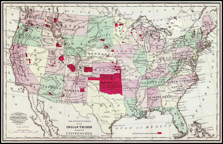
This 1868 vintage map, titled 'Locations of The Indian Tribes Within the United States,' offers a detailed cartographic record of Native American territories in Texas during a pivotal era. Created by government cartographers, it reflects the complex geopolitical landscape post-Civil War, with tribal boundaries, settlements, and migration routes meticulously charted. The map's lithographic technique and hand-coloring showcase 19th-century printing artistry, blending scientific precision with aesthetic appeal.
Historical Significance of the Texas Indian Tribes Map
Produced in 1868, this map documents the distribution of tribes like the Comanche, Apache, and Kiowa across Texas, serving as a critical resource for historians and ethnographers. Its creation coincided with westward expansion and federal Indian policies, making it a visual artifact of cultural displacement and resilience. The stylistic elements—such as engraved typography and symbolic icons—reveal period-specific cartographic conventions.
Artistic Details of the 1868 Tribal Map Print
As a fine art print, this piece captures the map's original texture and color palette, from faded earth tones to intricate linework. RedKalion's reproduction emphasizes archival quality, ensuring the historical nuances—like border annotations and geographic features—remain sharp and legible. It's ideal for educational displays or as a decorative accent that sparks conversation about indigenous heritage.
Print Specifications & Materials
- Available Sizes: 75×100 cm / 30×40″, 40×50 cm / 16×20″, 21×29.7 cm / 8×12″
- Paper Finishing: Matte, uncoated, natural white (off-white)
- Acid-Free: pH above 7 to prevent yellowing over time
- Paper Weight: 250 gsm (110 lb) | Thickness: 0.29 mm (11.4 mils)
- Sustainable Paper: FSC-certified
RedKalion's premium print of this map of Texas Indian tribes preserves a key historical document, offering collectors and enthusiasts a museum-quality piece that honors cartographic tradition and cultural memory.


Discover Unlimited Art Possibilities
At RedKalion, you can find virtually any artwork from any artist, available in a wide range of sizes to perfectly match your space.
If you didn’t find what you’re looking for, contact us at support@redkalion.com . We will source any artwork and produce it in any size and format you need, including art prints, posters, canvas, framed pieces, framed canvas, and more.
For dedicated art enthusiasts, we also offer handcrafted replicas of any artwork, carefully painted by highly skilled artists using traditional techniques.
For custom requests, contact us at support@redkalion.com .
What does this 1868 map of Texas Indian tribes depict?
It shows the locations and territories of Native American tribes in Texas, such as the Comanche and Apache, based on 19th-century surveys, with detailed boundaries and settlements.
What paper is used for this vintage map art print?
We use FSC-certified, acid-free 250 gsm matte paper to ensure archival longevity and accurate color reproduction for this historical map print.
How is this map print shipped and packaged?
It's shipped flat in protective packaging to prevent damage, with options for domestic and international delivery for fine art prints.
Will this print fade or yellow over time?
No, the acid-free paper and archival inks resist fading and yellowing, preserving the map's details for decades under proper display conditions.
What sizes are available for this Texas tribes map print?
Available in 75×100 cm, 40×50 cm, and 21×29.7 cm sizes to suit different display needs for vintage cartography art.
Who created the original 1868 Indian tribes map?
It was produced by U.S. government cartographers, likely for official records, reflecting federal efforts to document tribal lands during westward expansion.
What artistic style characterizes this vintage map?
It features lithographic printing with hand-coloring, showcasing engraved typography and symbolic icons typical of 19th-century American cartography.